the Guilford Greenway project
What is the Guilford Greenway project?
The Guilford Greenway project is a proposal to establish a new hiker-biker trail a few miles north of Washington DC. The pedestrian and biking trail would run largely east-west, connecting Hyattsville, University Park, College Heights Estates, College Park, and the University of Maryland. It would provide pedestrian/biking access to transit hubs, including Metro, the Purple Line, and MARC commuter rail stations. The trail would provide very desirable east-west connectivity to existing hiker/biker trails and would connect existing parks to the east and the west. The trail would feature natural areas, being located within an existing environmental corridor, meandering along a small stream and passing through forested areas of the region.
The Guilford Greenway project is a proposal to establish a new hiker-biker trail a few miles north of Washington DC. The pedestrian and biking trail would run largely east-west, connecting Hyattsville, University Park, College Heights Estates, College Park, and the University of Maryland. It would provide pedestrian/biking access to transit hubs, including Metro, the Purple Line, and MARC commuter rail stations. The trail would provide very desirable east-west connectivity to existing hiker/biker trails and would connect existing parks to the east and the west. The trail would feature natural areas, being located within an existing environmental corridor, meandering along a small stream and passing through forested areas of the region.
|
Why this project, and why now?
Hiker-biker trails provide many benefits to communities. They allow pedestrians and bikers to travel along routes that are protected from cars. They often traverse natural or semi-natural settings, providing corridors that benefit both humans and wildlife. Hiker-biker trails encourage travel that is healthier and safer than car travel, they promote more sustainable commuting, and they provide valuable areas for recreation and leisure. The suburbs of Washington DC continue to see rapid development, and opportunities to establish hiker-biker trails are rapidly diminishing. Projects such as these take many years to go from plan to reality. This is a critical time to plan and advocate for such a trail. |
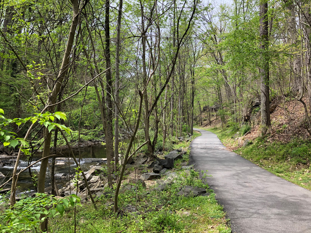
an existing trail in the College Park area (Northwest Branch Trail)
|
Where would the Guilford Greenway trail run?
The proposed Guilford Greenway trail would run largely east-west just south of the University of Maryland, from the Northwest Branch Trail in Hyattsville to the Trolley Trail in College Park. Much of the trail would run along a small stream, Guilford Run, which ultimately flows into the Anacostia River.
The proposed Guilford Greenway trail would run largely east-west just south of the University of Maryland, from the Northwest Branch Trail in Hyattsville to the Trolley Trail in College Park. Much of the trail would run along a small stream, Guilford Run, which ultimately flows into the Anacostia River.
The Guilford Greenway would add highly desirable east/west connectivity to the area's existing pedestrian/biking infrastructure.
The Guilford Greenway would connect two hiker biker trail systems, the Northwest Branch Trail system to the west and the Trolley Trail and Northeast Branch Trail system to the east. Below is a satellite view of the area, highlighting existing hiker/biker trails (blue) and the proposed Guilford Greenway trail (dashed green).
The Guilford Greenway would connect two hiker biker trail systems, the Northwest Branch Trail system to the west and the Trolley Trail and Northeast Branch Trail system to the east. Below is a satellite view of the area, highlighting existing hiker/biker trails (blue) and the proposed Guilford Greenway trail (dashed green).
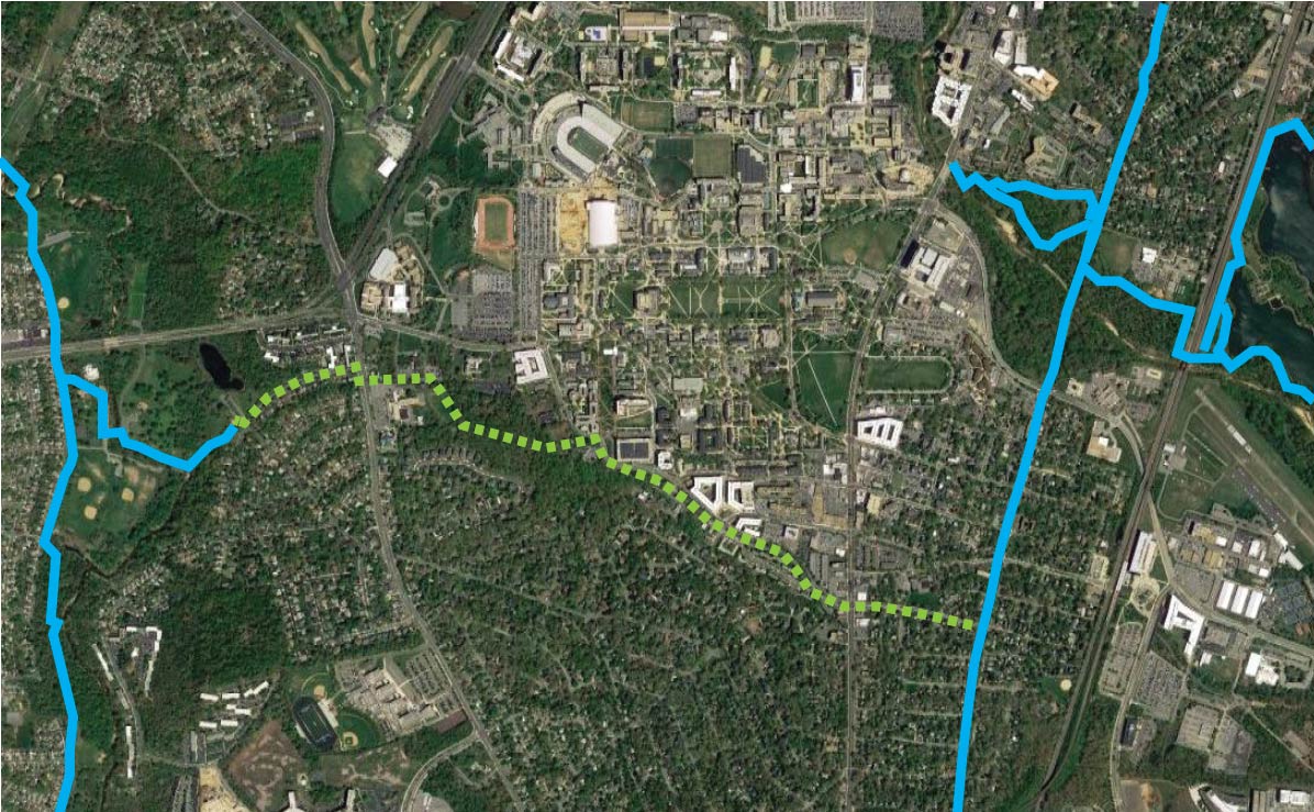
The proposed Guilford Greenway trail (dotted green line) would run largely east-west and would connect the Northwest Branch trail system to the west (blue lines on left) to the Trolley Trail in Calvert Hills/Old Town and the Northeast Branch trail system to the east (blue lines on right).
|
The Guilford Greenway would use an existing environmental corridor.
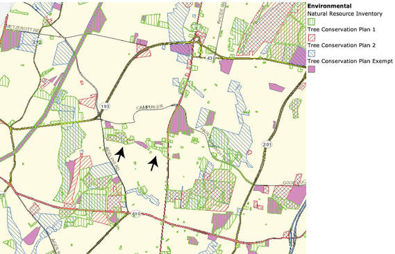
The Guilford Greenway would run through a land corridor that already has environmental designation. The Prince George's County Atlas (PGAtlas) shows that the Guilford Run corridor (indicated by arrows on this image) represents an already existing east-west environmental corridor, connecting Adelphi Rd to Route 1/Baltimore Avenue. This corridor represents a unique and ideal route for a hiker/biker greenway. |
|
|
The Guilford Greenway would enhance green infrastructure in the area.
It would feature beautiful natural resources that are becoming scarce in our area, including a small stream (Guilford Run) and a remnant forest (Guilford Woods). A pedestrian/biking trail that uses Guilford Run as a green corridor would be a significant place-making asset for the area. |
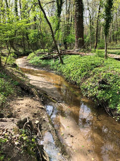
Guilford Run
|
Connections
The Guilford Greenway would directly connect or be near many important components of the local community, including...
The Guilford Greenway would directly connect or be near many important components of the local community, including...
|
Natural Areas and Parks
|
Housing
|
Transit
|
Amenities
|
Schools
|
Have comments or suggestions? Want to stay informed about this project? Want to help make this project a reality?
College Park is undergoing rapid development and a number of projects currently planned or being considered along this corridor will strongly impact whether a protected hiker-biker trail can be established along this route. Without vision and engagement, opportunities to retain this corridor may disappear. If you have comments or suggestions, want to stay informed about the project, or want to help make this vision a reality, please email us at: [email protected]
College Park is undergoing rapid development and a number of projects currently planned or being considered along this corridor will strongly impact whether a protected hiker-biker trail can be established along this route. Without vision and engagement, opportunities to retain this corridor may disappear. If you have comments or suggestions, want to stay informed about the project, or want to help make this vision a reality, please email us at: [email protected]
